
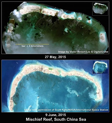
Satellite imagery from June 5, 2015 shows China has expanded its land fill of Subi Reef by 74 percent in less than two months, adding an average of eight acres of surface per day on that reef alone. Mischief Reef, larger than Subi, is now more than half filled in, according to a June 9, 2015 NASA image.
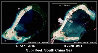
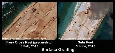
Subi’s expansion, to 3.87 square kilometers (955 acres*), has proceeded by extension along the reef as well as by widening. As previously reported, a straight segment of land fill on Subi is long enough to accommodate an airstrip more than three kilometers long; terrain grading patterns on this segment resemble China’s preparations for a now-constructed airstrip at Fiery Cross Reef, making it highly likely that China will build an airstrip at Subi as well.

The June 16 announcement by China’s Foreign Ministry spokesperson Lu Kang that “the land reclamation project of China’s construction on some stationed islands and reefs of the Nansha (Spratly) Islands will be completed in the upcoming days” deserves to be treated with skepticism. Earlier obfuscation from Beijing defended its new installations as shelter for fishermen.
Subi, Mischief and Fiery Cross reefs are part of the disputed Spratly Islands, portions of which are claimed by Vietnam, the Philippines, China, Taiwan, Malaysia and Brunei. Subi lies 430 kilometers off the Philippines’ Palawan Island, and 930 kilometers from China’s nearest coastline at Hainan Island.
China’s land filling at four other Spratly Reefs – Gaven, Hughes, Cuarteron and Johnson South – has largely ceased, but intensive construction of facilities continues. On May 28, the U.S. government reported it had observed two mobile artillery units on one of China’s Spratly installations a month prior, but that they had subsequently been removed or concealed. (According to @Rajfortyseven and the South China Sea Research Forum, the artillery was positioned at Johnson South Reef, also called Chigua.) Each of Gaven, Hughes, Cuarteron, and Johnson South reefs now has a 5-meter by 40-meter concrete ramp leading to a 2nd/3rd story structure connected to a large new building. A ramp-and-“garage” arrangement of these dimensions could accommodate mobile artillery units and permit their concealment as well as provide sheltered elevation above storm surge in the event of a typhoon.